Where to See the 2017 Total Solar Eclipse, State by State
Georgia
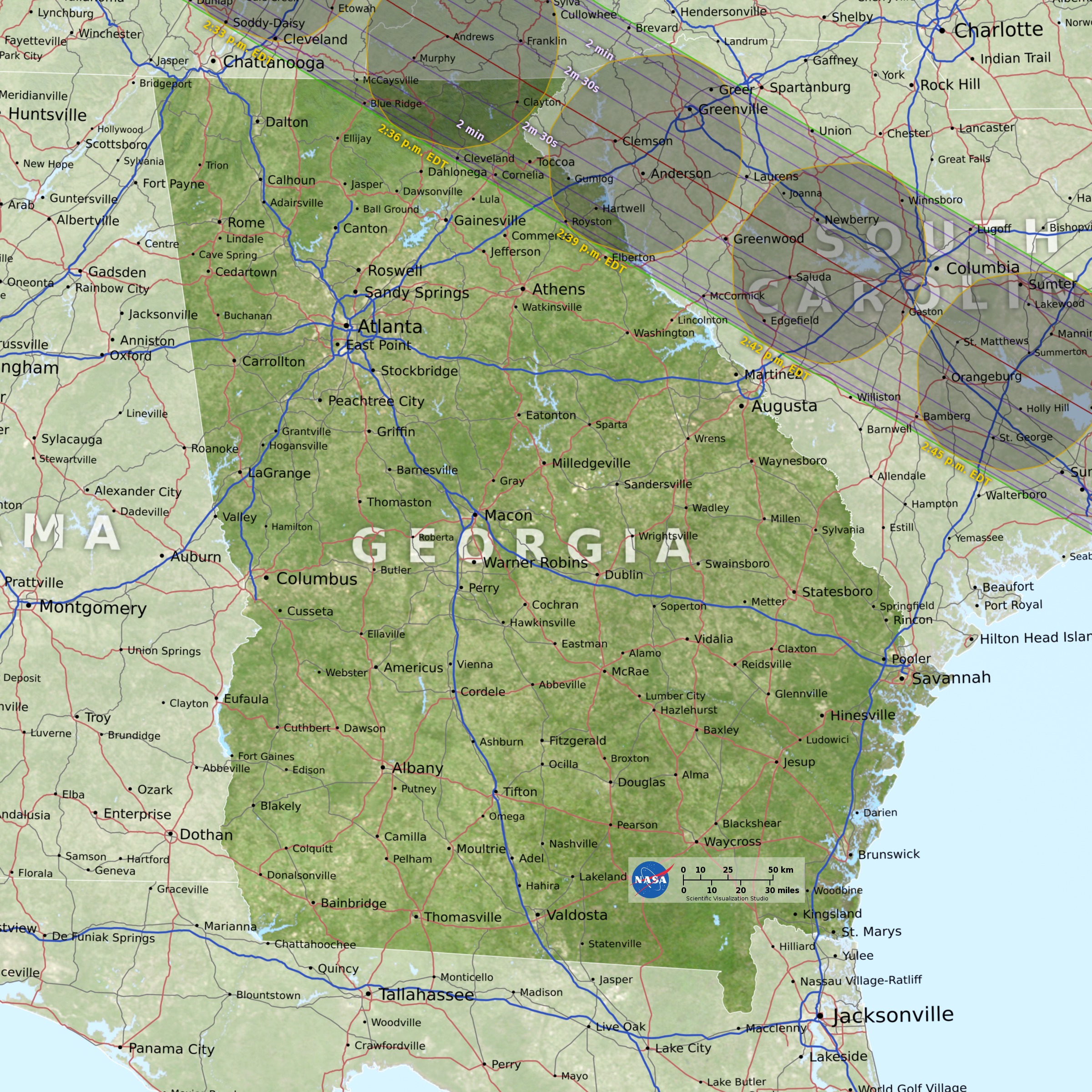
Only the extreme northeast corner of the Peach State will be touched by the moon's dark shadow between 2:34 and 2:40 p.m. local time (EDT), which is why in a state of more than 10 million people, only about 194,000 are in the total eclipse zone. The Atlanta metropolitan area lies about 85 miles outside the eclipse track to the southwest. But a 75-minute drive on Interstate Highway 85, to just south of Indian Creek, will put you inside the path of totality. The eclipse will be reaching its peak toward the middle of the afternoon, but you should strongly consider leaving well before noontime to avoid any possible traffic jam that might occur if lots of folks suddenly decide to make a last-minute dash to see the total eclipse. Those who stay in Atlanta will see a 97 percent partial eclipse at 2:36 p.m. EDT. The best place in Georgia to watch the eclipse will be in Rabun County, where the county seat of Clayton (pop. 2,300) will be treated to 2 minutes and 34 seconds of total eclipse, beginning at 2:35 p.m. The area around Clayton has long been the location for a number of camps for young people, mostly operated during the summertime. Just north of Clayton is the Black Rock Mountain State Park, where totality will last 2 seconds longer.
North Carolina
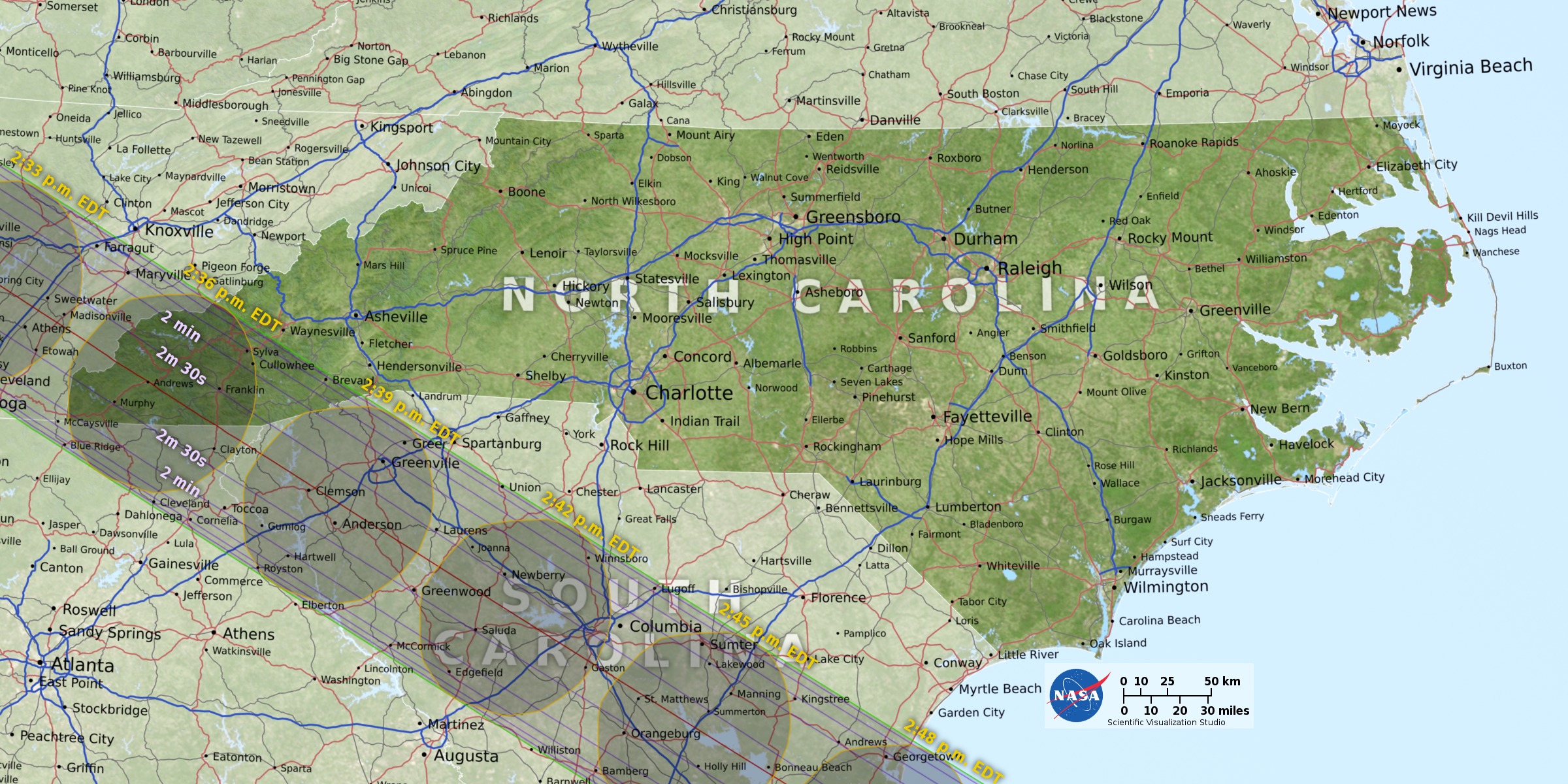
Like Georgia, only a small part of the Tarheel State will experience totality. The path of totality will slide across the western end of the state, passing over the Great Smoky and Blue Ridge mountains. A large part of the Great Smoky Mountains National Park is in the path. The center of the eclipse track crosses through Graham, Cherokee, Clay and Macon counties. Most of the towns and communities up here are rather small, which is why the number of people who fall within the path of the total eclipse in North Carolina is only about 175,000. Franklin, the county seat of Macon (pop. 3,900), is the largest local city in the eclipse path and is surrounded by beautiful streams, waterfalls, mountains, hills and valleys. There are plenty of trails for hiking as well as plenty of fishing, hunting, rafting and kayaking, and the views are said to be breathtaking. Franklin will experience 2 minutes and 30 seconds of daytime darkness, starting at 2:35 p.m. EDT. The largest city in western North Carolina is Asheville, but it is 25 miles outside the eclipse path, so the 92,000 residents will see the moon cover 99.2 percent of the sun at 2:37 p.m.
South Carolina
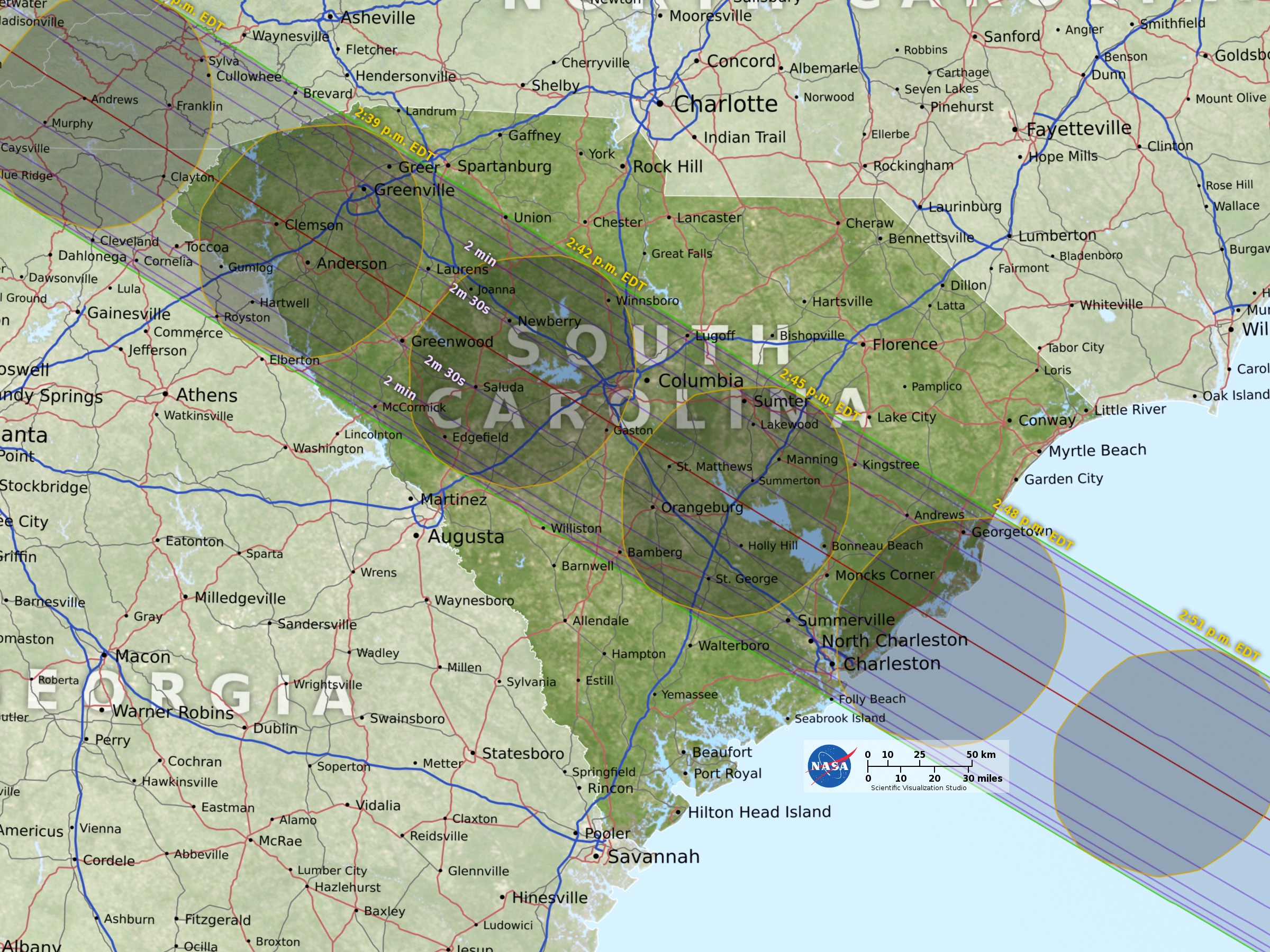
The path of totality cuts from northwest to southeast through the Palmetto State between 2:36 and 2:49 p.m. EDT. Except for Missouri, South Carolina has more people in the path of totality — 3 million — than any other state. That's because four of its six largest cities will be darkened by the moon's umbra. This includes its state capital and largest city, Columbia. Totality there begins at 2:41 p.m. local time and lasts 2 minutes and 29 seconds. Four minutes earlier, the umbra will pass over Greenville, bringing with it 2 minutes and 10 seconds of midafternoon darkness. And at 2:46 p.m., the moon's shadow will pass over the historic city of Charleston, an important Atlantic seaport. Here, you would see a total eclipse that will last 1 minute and 31 seconds. One of the main attractions of this city is the Magnolia Plantation and Gardens, considered to be among the most beautiful gardens in America. And at the same time, nearby North Charleston will also be experiencing totality; the residents' view of the darkened sun will last 17 seconds longer than totality in Charleston. The shadow will also pass over the 26,276-acre Congaree National Park, which contains the largest tract of old-growth bottomland hardwood forest left in the United States. Totality here arrives around 2:42 p.m. and will last about 2 minutes 30 seconds.
States with Glancing blows
If you've counted all the states in the totality path to this point, they have numbered 12.
But we said there were a total of 14. What about those final two?
Well . . . there isn't much to say about them.
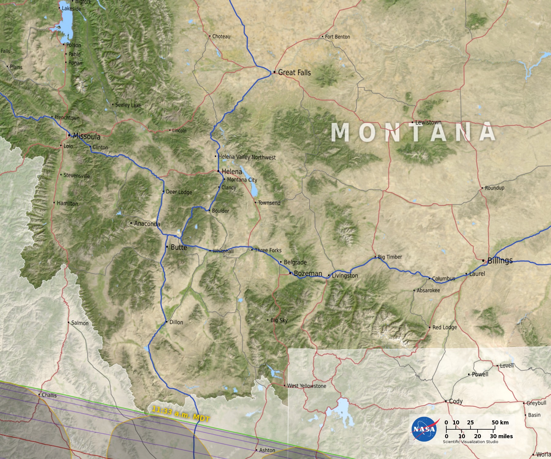
The moon's shadow will just barely clip the southernmost tip — some call it the "beard" — of the Big Sky State of Montana. This happens in Beaverhead County, which borders Idaho's Bitterroot Mountain Range and the Continental Divide. But as best as I can tell there are no towns or cities that are within this tiny segment of Montana that will be briefly touched by the shadow at 11:32 a.m. MDT. At most, totality will last about 50 seconds. The nearest town is Lima (pop. 230), just off of Interstate Highway 15, which lies about 15 miles outside the totality path to the northeast.
And then there is the Hawkeye State of Iowa. In a tiny corner of Fremont County, immediately adjacent to the Missouri River, and very near to where the borders of Missouri, Nebraska and Iowa meet, the moon's shadow will briefly pass by at 1:05 p.m. CDT, bringing, at most, about 30 seconds of total eclipse. Based on satellite images, much of this region appears to be forest and grassland. The nearby city of Hamburg (pop. 1,030) is just outside of the path. But get on Interstate Highway 29 and drive just over 2 miles to the south, past the Missouri state line, and you'll be inside the eclipse path.
Shadow's Last State is S.C.
The moon's umbra will bid the United States a fond farewell as it moves off the South Carolina coast and out over the Atlantic Ocean at 2:49 p.m. EDT. It will then spend the next 73 minutes sweeping over open water, perhaps encountering a passenger cruise ship, or maybe a few fishing trawlers along the way, until it finally slides off the surface of the Earth about 375 miles to the southwest of the island nation of Cape Verde at 4:02 p.m. EDT.
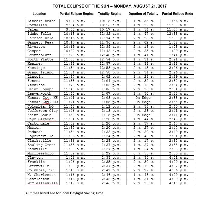
In the table above, I have calculated specific details of the eclipse for 40 locations that are inside the path of totality and will witness the grand spectacle of a total eclipse of the sun. For each location, you will find the local daylight time for the start of the partial eclipse, followed by the time when the total eclipse will start, then the duration of totality in minutes ("m") and seconds ("s") and finally, the local daylight time for the end of the partial eclipse.
For more details about the eclipse, be sure to check out NASA eclipse webpage at: https://eclipse2017.nasa.gov/ as well as the Great American Eclipse website at: https://www.greatamericaneclipse.com/
Joe Rao serves as an instructor and guest lecturer at New York's Hayden Planetarium. He writes about astronomy for Natural History magazine, the Farmers' Almanac and other publications, and he is also an on-camera meteorologist for Fios1 News in Rye Brook, NY.
Follow us @Spacedotcom, Facebook and Google+.
Join our Space Forums to keep talking space on the latest missions, night sky and more! And if you have a news tip, correction or comment, let us know at: community@space.com.
Get the Space.com Newsletter
Breaking space news, the latest updates on rocket launches, skywatching events and more!

Joe Rao is Space.com's skywatching columnist, as well as a veteran meteorologist and eclipse chaser who also serves as an instructor and guest lecturer at New York's Hayden Planetarium. He writes about astronomy for Natural History magazine, Sky & Telescope and other publications. Joe is an 8-time Emmy-nominated meteorologist who served the Putnam Valley region of New York for over 21 years. You can find him on Twitter and YouTube tracking lunar and solar eclipses, meteor showers and more. To find out Joe's latest project, visit him on Twitter.
