NOAA expects up to 5 major hurricanes in 2025: 'Be prepared'
The 2025 Atlantic Hurricane season expected to be busier than normal, according to NOAA forecasters.

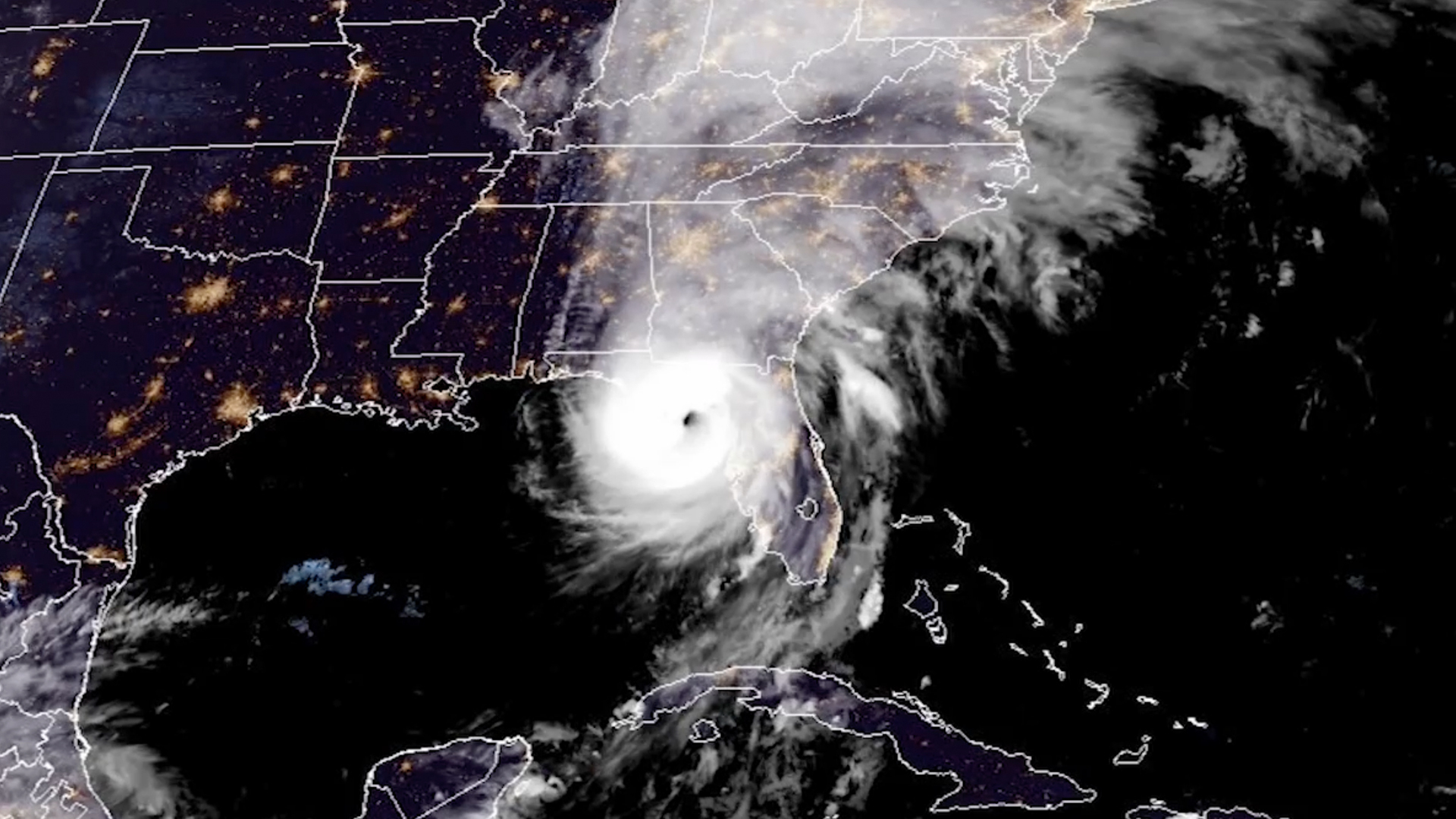
Many people are still recovering from devastating storms during the 2024 Atlantic hurricane season even as this year's season began this week on June 1. And like last year's, the 2025 hurricane season is anticipated to be busier than normal.
The Atlantic hurricane season runs from June 1 to Nov. 30 every year, and before it begins, forecasters at the Climate Prediction Center (CPC), part of the U.S. National Oceanic and Atmospheric Administration's (NOAA) National Weather Service, share their thoughts on what type of storm activity we could see.
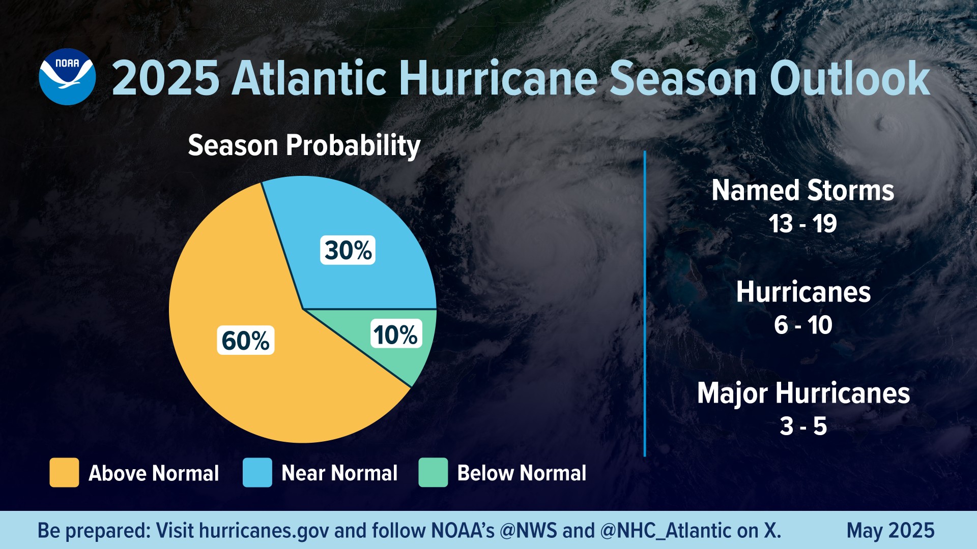
For the 2025 season, CPC researchers forecast that chances sit at 60% that it will be "above normal," with the number of named storms between 13 to 19 (where wind speeds get up to a minimum of 39 mph, or 63 kph). Of those named storms, six to ten are anticipated to reach hurricane strength (winds of at least 74 mph, or 119 kph), and between three to five will develop into major hurricanes.
Major hurricanes are defined as those that grow to at least Category 3 on the Saffir-Simpson scale, meaning sustained winds reach a minimum of 111 mph (179 kph). Typically, for a hurricane season to be "normal," there will be 14 named storms, where seven strengthen into hurricanes and three are major.
These storms have the potential to impact millions of people, NOAA leaders say. "As we witnessed last year with significant inland flooding from hurricanes Helene and Debby, the impacts of hurricanes can reach far beyond coastal communities," Laura Grimm, acting NOAA Administrator, said in a statement. "NOAA is critical for the delivery of early and accurate forecasts and warnings, and provides the scientific expertise needed to save lives and property."

To determine how busy the season could be, forecasters consider a variety of factors. This year, the prediction was made based on a persistence of neutral El Niño-Southern Oscillation (ENSO) conditions, ocean temperatures trending above average, the likelihood of weak wind shear, and a possibility of increased activity from the West African monsoon (this is where hurricanes in the Atlantic primarily originate).
With the continuation of elevated ocean temperatures and decreased trade winds, there's more energy available to fire up tropical systems and less of a chance storms will be disrupted or "torn apart" while they are forming. Also, with the possibility that the West African monsoon will shift to the north, this would set the stage for the production of tropical waves that can turn into powerful and long-duration systems in the Atlantic.
Breaking space news, the latest updates on rocket launches, skywatching events and more!
NOAA leaders stress that the 2024 season should serve as a reminder of why forecasting is so vital to ensure that as many people are as prepared as possible during hurricane season.
"In my 30 years at the National Weather Service, we've never had more advanced models and warning systems in place to monitor the weather," Ken Graham, NOAA's National Weather Service Director, said in a statement. "This outlook is a call to action: be prepared. Take proactive steps now to make a plan and gather supplies to ensure you're ready before a storm threatens."
It is important to note that the outlook NOAA puts out every season refers specifically to the development of storms, and it is not a prediction for landfalling storms. There will be another update in early August from NOAA's CPC to the seasonal outlook, which will account for how the season is progressing, which also takes place just before the climatological peak of the season.
Join our Space Forums to keep talking space on the latest missions, night sky and more! And if you have a news tip, correction or comment, let us know at: community@space.com.

Meredith is a regional Murrow award-winning Certified Broadcast Meteorologist and science/space correspondent. She most recently was a Freelance Meteorologist for NY 1 in New York City & the 19 First Alert Weather Team in Cleveland. A self-described "Rocket Girl," Meredith's personal and professional work has drawn recognition over the last decade, including the inaugural Valparaiso University Alumni Association First Decade Achievement Award, two special reports in News 12's Climate Special "Saving Our Shores" that won a Regional Edward R. Murrow Award, multiple Fair Media Council Folio & Press Club of Long Island awards for meteorology & reporting, and a Long Island Business News & NYC TV Week "40 Under 40" Award.
You must confirm your public display name before commenting
Please logout and then login again, you will then be prompted to enter your display name.
